

How Many Seas Are in India
F
Discover verified facts, data, and insights about India’s states, culture, economy, education, and more — all in one place at FactBharat.
Search for a command to run...
Discover verified facts, data, and insights about India’s states, culture, economy, education, and more — all in one place at FactBharat.
No comments yet. Be the first to comment.
Moving to the USA from India is a dream for many. Whether you want to study, work, or live with family, the process can seem complex. But with the right information, you can plan your move confidently. I’ll guide you through the key steps and options...
Opening a college in India is a dream for many educators and entrepreneurs who want to contribute to the country’s education sector. If you are one of those who want to start a college, you need to understand the process clearly. It involves several ...
Opening a hospital in India is a significant and rewarding venture. If you’ve ever wondered how to start one, you’re in the right place. Whether you’re a healthcare professional, entrepreneur, or investor, understanding the process is crucial. You’ll...
Opening a medical store in India can be a rewarding business opportunity. You get to serve your community by providing essential medicines and healthcare products. If you are thinking about starting a medical store, you might wonder where to begin an...
Opening a restaurant in India can be an exciting and rewarding venture. Whether you dream of serving traditional Indian dishes or international cuisine, the process involves careful planning and understanding of local regulations. If you’re ready to ...
FactBharat | Insights About India
2558 posts
Discover verified facts, data, and insights about India’s states, culture, economy, education, and more — all in one place at FactBharat.
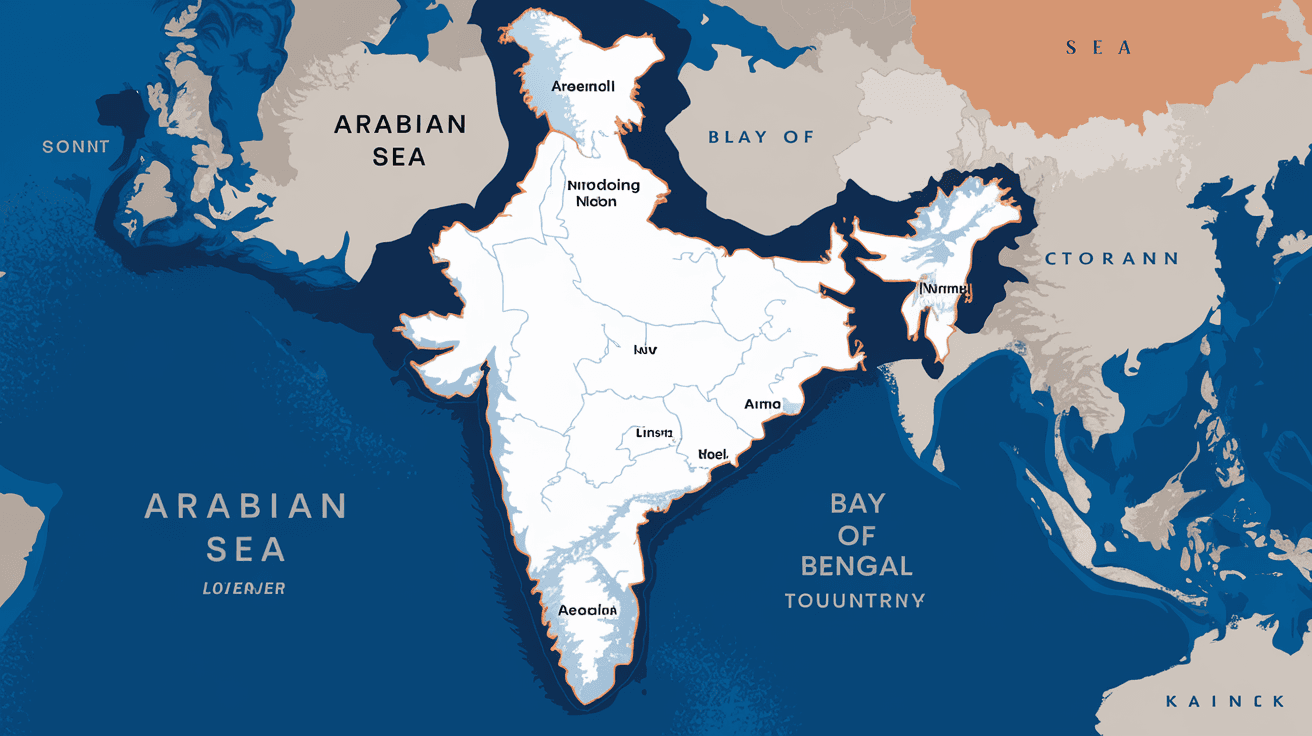
When you think about India’s geography, you might picture vast mountains, rivers, and deserts. But have you ever wondered how many seas touch India’s shores? Understanding this helps you appreciate India’s rich maritime history and its strategic location. You’ll find that India is bordered by more than just one sea, each playing a unique role in the country’s culture, economy, and environment.
In this article, I’ll walk you through the seas that surround India, explain their importance, and share some interesting facts. Whether you’re curious about geography or planning a trip to India’s coastal regions, this guide will give you clear and simple answers.
India is bordered by three major seas. These seas are part of the larger Indian Ocean region and define India’s extensive coastline. The three seas are:
Each sea touches different states and has its own unique features. Together, they shape India’s climate, trade routes, and marine biodiversity.
The Arabian Sea lies to the west of India. It stretches from the coast of Gujarat and Maharashtra down to Kerala and the Lakshadweep Islands. This sea is part of the northern Indian Ocean and is one of the busiest maritime routes in the world.
The Arabian Sea has been crucial for trade for centuries. Ancient Indian traders used it to connect with the Roman Empire, the Arabian Peninsula, and East Africa. Today, it remains vital for India’s economy and naval security.
On the east coast, India is bordered by the Bay of Bengal. This sea is the largest bay in the world and extends from West Bengal down to Tamil Nadu and the Andaman and Nicobar Islands.
The Bay of Bengal is also prone to cyclones, which can impact millions of people living in coastal areas. Despite this, it remains a lifeline for trade and fishing communities.
The Laccadive Sea lies to the southwest of India, between the southwestern coast and the Maldives. It is smaller than the Arabian Sea and Bay of Bengal but is equally important.
This sea is less talked about but plays a key role in India’s southern maritime activities, including fishing and tourism.
Understanding how many seas border India is more than just a geography lesson. These seas impact many aspects of life in India:
Knowing about these seas helps you appreciate India’s connection to the wider world and its natural environment.
India has a coastline of about 7,500 kilometers, making it one of the countries with the longest coastlines in the world. This coastline is divided among the three seas:
| Sea | Approximate Coastline Length | Key Coastal States |
| Arabian Sea | ~2,000 km | Gujarat, Maharashtra, Goa, Kerala |
| Bay of Bengal | ~2,600 km | West Bengal, Odisha, Andhra Pradesh, Tamil Nadu |
| Laccadive Sea | ~1,100 km | Kerala, Karnataka |
The remaining coastline includes the islands of Lakshadweep and Andaman & Nicobar, which are surrounded by these seas.
India’s seas are home to several important island groups:
These islands are strategic for India’s defense and also rich in biodiversity. They attract tourists and support fishing communities.
While India’s seas are vital, they face environmental threats:
Efforts are underway to protect these seas through marine parks, pollution control, and sustainable fishing laws.
India’s seas are used for many purposes:
These activities show how important the seas are for India’s growth and security.
So, how many seas are in India? The answer is three: the Arabian Sea, the Bay of Bengal, and the Laccadive Sea. Each sea touches different parts of India’s vast coastline and plays a unique role in the country’s economy, climate, and culture.
Understanding these seas helps you see how India connects with the world through its waters. Whether it’s trade, fishing, or tourism, these seas are vital to India’s past, present, and future. Next time you think about India’s geography, remember the three seas that shape its coastal life.
India is bordered by three seas: the Arabian Sea, the Bay of Bengal, and the Laccadive Sea.
The Arabian Sea lies along India’s west coast, touching states like Gujarat, Maharashtra, and Kerala.
The Bay of Bengal is the largest bay in the world and supports rich biodiversity, including the Sundarbans mangrove forest.
The Laccadive Sea is to the southwest of India, near Kerala and Karnataka, and extends towards the Maldives.
India’s seas are crucial for trade, fishing, climate regulation, tourism, and national security.