

How Many Physiographic Divisions Are There in India
F
Discover verified facts, data, and insights about India’s states, culture, economy, education, and more — all in one place at FactBharat.
Search for a command to run...
Discover verified facts, data, and insights about India’s states, culture, economy, education, and more — all in one place at FactBharat.
No comments yet. Be the first to comment.
Moving to the USA from India is a dream for many. Whether you want to study, work, or live with family, the process can seem complex. But with the right information, you can plan your move confidently. I’ll guide you through the key steps and options...
Opening a college in India is a dream for many educators and entrepreneurs who want to contribute to the country’s education sector. If you are one of those who want to start a college, you need to understand the process clearly. It involves several ...
Opening a hospital in India is a significant and rewarding venture. If you’ve ever wondered how to start one, you’re in the right place. Whether you’re a healthcare professional, entrepreneur, or investor, understanding the process is crucial. You’ll...
Opening a medical store in India can be a rewarding business opportunity. You get to serve your community by providing essential medicines and healthcare products. If you are thinking about starting a medical store, you might wonder where to begin an...
Opening a restaurant in India can be an exciting and rewarding venture. Whether you dream of serving traditional Indian dishes or international cuisine, the process involves careful planning and understanding of local regulations. If you’re ready to ...
FactBharat | Insights About India
2558 posts
Discover verified facts, data, and insights about India’s states, culture, economy, education, and more — all in one place at FactBharat.
India's vast and diverse landscape is shaped by its unique physiographic divisions. If you've ever wondered how many physiographic divisions are there in India, you're about to explore the answer. These divisions help us understand the country's geography, climate, and natural resources better.
In this article, we'll walk you through the seven major physiographic divisions of India. You'll learn what makes each division special and how they contribute to India's rich natural heritage. Whether you're a student, traveler, or just curious, this guide will give you a clear picture of India's physical geography.
Physiographic divisions refer to the natural physical regions of a country. They are based on landforms, terrain, and geological structures. In India, these divisions help categorize the landscape into distinct zones like mountains, plateaus, plains, and coastal areas.
Understanding these divisions is important because:
India's diverse physiography is a result of its location on the Indian tectonic plate and its varied geological history.
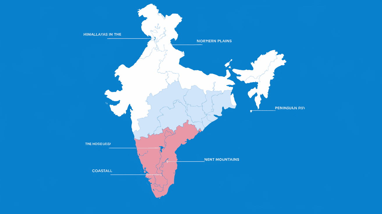
India is broadly divided into seven major physiographic divisions. Each division has unique features, climate, and natural resources. These divisions are:
Let's explore each of these divisions in detail.
The Northern Mountains are among the most prominent features of India's geography. They include the mighty Himalayas, which stretch across the northern border of India.
South of the Himalayas lie the vast Northern Plains, formed by the alluvial deposits of rivers flowing from the mountains.
The Peninsular Plateau is one of the oldest landforms in India, covering most of southern India.
Also known as the Thar Desert, this division lies in the northwestern part of India, mainly in Rajasthan.
India's coastline stretches over 7,500 kilometers, forming the Coastal Plains along the Arabian Sea and Bay of Bengal.
India has two major island groups: the Andaman and Nicobar Islands in the Bay of Bengal and the Lakshadweep Islands in the Arabian Sea.
While the Himalayas are part of the Northern Mountains, sometimes they are considered a separate physiographic division due to their vastness and complexity.
Knowing the physiographic divisions of India helps you appreciate the country's natural diversity. It also aids in:
For example, the Northern Plains' fertile soil supports India's food production, while the Peninsular Plateau's mineral wealth drives industry.
| Division | Location | Key Features | Importance |
| Northern Mountains | Northern border | Himalayas, high peaks, cold climate | Natural barrier, biodiversity |
| Northern Plains | South of Himalayas | Alluvial plains, fertile soil | Agriculture, dense population |
| Peninsular Plateau | Southern India | Old rocks, hills, mineral-rich | Mining, agriculture, biodiversity |
| Indian Desert | Northwestern India | Sandy, arid, extreme temperatures | Unique flora/fauna, minerals |
| Coastal Plains | Arabian Sea & Bay of Bengal | Narrow/wide plains, tropical climate | Ports, fishing, agriculture |
| Islands | Bay of Bengal & Arabian Sea | Volcanic and coral islands | Tourism, defense, marine life |
| Himalayan Region | Northern Mountains (special) | Glaciers, alpine climate | Water source, culture, ecology |
So, how many physiographic divisions are there in India? The answer is seven major divisions, each with its own unique landscape and significance. From the towering Himalayas to the vast Northern Plains, the arid Thar Desert to the lush Coastal Plains, India's geography is incredibly diverse.
Understanding these divisions helps you see how nature shapes life in India. It influences everything from climate and agriculture to culture and economy. Next time you think about India's landscape, remember these seven divisions that make the country so special.
India has seven major physiographic divisions: Northern Mountains, Northern Plains, Peninsular Plateau, Indian Desert, Coastal Plains, Islands, and sometimes the Himalayan Region separately.
The Northern Plains are the largest physiographic division, covering about 43% of India's total area and supporting dense population and agriculture.
The Peninsular Plateau is the large, ancient landmass in southern India, rich in minerals and divided into the Central Highlands and Deccan Plateau.
The Himalayas act as a natural barrier, influence climate, are the source of major rivers, and support biodiversity and tourism.
The Indian Desert, or Thar Desert, is sandy, arid, with extreme temperatures and low rainfall, supporting unique flora and fauna adapted to dry conditions.